Flood Mapping Service
Townsville City Council now has newer and more accurate flood information available on the Flood Information Portal.
The TownsvilleMAPS – Flooding service allows users to review online flood mapping to:
- assess the risk of flood in their area
- examine flood extents in an area of interest
- determine flood levels for building and development works.
Technical reports for the flood studies will be available to view in the "Flood Study Areas" layer in TownsvilleMAPS in the near future. They are also available on the Flood Studies page.
Accessing TownsvilleMAPS – Flooding
More Information
Explanatory Notes
The following two parts of explanatory notes include information about:
- flood maps, limitations, what the maps don't show, where to find more information, and definitions: Part 1 (PDF)
- searching for properties, interpreting information, and finding flood heights and depths: Part 2 (PDF).
TownsvilleMAPS
For more information on TownsvilleMAPS please visit the TownsvilleMAPS Mapping Service page.
Capital Works Program
To keep Townsville growing, Council is actively involved in the delivery of projects to provide vital infrastructure and exciting development opportunities.

Seniors Expo 2026
Join us at Townsville Stadium and connect with a wide range of services, organisations and local businesses supporting health and wellbeing, lifestyle and independence, social, leisure and community connections.
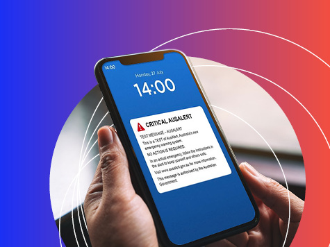
AusAlert National Test
AusAlert will be ready to use in October, but before it launches, the system needs to be tested across Australia. On Monday 27 July 2026 at 2pm, a test alert will be sent to your mobile device.

The Percivals 2026
The Percivals 2026 highlights the power of portraiture to capture emotion, identity and connection. From emerging artists to established names, this year’s exhibition offers a compelling snapshot of contemporary Australia.

Wintergarden Festival of Music
Pack a picnic and rug and settle in on the lawns at Queens Gardens for the Wintergarden Festival of Music.